Jun 11, 2014

City Council Meeting Notes Catch-Up

The Little Canada City Council notes are always a little depressing. After years of monitoring our city’s management, not thinking about the direction our city is heading for a few months has been relaxing. I've been out of state for a while and this is the moment I have to catch up on the Little Canada City Council meeting notes regarding our lake and neighborhood. Here's a scattering of topics that have come up over the last year:

2014

Nothing new, so far, regarding any of the Savage Lake or I35E noise issues. Conversations about MNDOT’s noise barrier constructions along the new, widened I35E corridor have been notably absent. While I was in New Mexico, I received a call from a Star Tribune reporter regarding the comments I’ve made about the freeway noise in our neighborhood. After demoting/promoting me from an educator/engineer/acoustician into a “retired electrician,” the reporter briefly summarized our noise problems into a couple of sound bites. I guess some attention to our problem is better than none, but not much. The reporter semi-quoted me with, “’We’ve picked up 6 to 8 decibels [of noise] in our back yard just in the past few years,’ he [me] said. ‘When traffic is at its peak, you can’t have a normal conversation in our back yard. We have to shout at each other.’” Unfortunately, he left out the fact that the increases have put our backyards well above the sadly conservative and outdated OSHA guidelines well known to cause hearing damage and a variety of health problems.

To protect the noise-makers, OSHA and the EPA (and all MN state regulators) use “A-weighting.” A conveniently forgotten fact about the noise weighting curves is that they were designed to be used with specific noise levels; accounting for the fact that our hearing response is dependent on noise levels. Even more important to remember, all of the weighting curves were determined by sine wave testing, not broadband noise exposure. So, A-weighting was intended for “extremely low level” signals, –55dB unweighted and below. C-weighting is appropriate for 80dB and above noise exposure. The “advantage” of using A-weighting for everything is that A-weighting deletes/attenuates the low frequency content of the noise measurement, allowing for considerably more noise than is actually sensed (or causing damage) in the specification. If you look at the yellow graph line, vs. the red one, you’ll see that an A-weighted 30Hz signal can be ~25dB louder for the same weighting reading in C-weighting. The overwhelming majority of noises from roadway traffic are low frequency, especially at distance. While A-weighting makes reducing noise levels much easier for the noise makers and regulators, it is inappropriate in most public safety standards. If you still labor under the drunken delusion that government regulations hinder industry, you’ll have to ignore all of the above information to maintain your fantasies. Most regulations are intended to protect people with money and power from being sued by people without.

Stay tuned. I’ve started a 24-hour noise study in our backyard. I’ll post the results when I have some data to talk about.

2013

12/18/2013

“Brian Singletary indicated that his property taxes are doubling for 2014. Singletary asked the basis for this increase. He also noted that he lives near Highway 36 and expressed concern about the noise from this highway. The City Administrator noted that the increase in Singletary’s property taxes is the result of his new home reaching a fully taxed status for 2013, pay 2014 property taxes. The Administrator also explained that the City has no authority relative to sound walls along freeways, and this is an issue that is under MN DOT’s control. The Administrator reported that MN DOT has many standards in place that will trigger the construction of noise walls. He noted that given there are no changes proposed along this portion of Highway 36, therefore, MN DOT standards would not be triggered to put up a noise wall.”

11/25/2013

“. . . Mayor Blesener noted that the City hired SEH Engineering to conduct a traffic study on LaBore Road from Edgerton Street to County Road D. The City Administrator presented the results of that study at the last Council meeting. . . Sohrweide reported that studies have indicated that if drivers feel a 4-way stop is unwarranted, in time they will only slow for the stop sign or do a slow roll-through. Sohrweide also pointed out that this area of LaBore Road is basically a residential through street. . . ” Which begs the question, if we know pointless multi-direction stops get ignored, what’s the purpose of the trio of stop signs at Jackson and Lake Streets? Can you say, “Tax collection disguised as traffic violations?”

May 23, 2014

Dead Deer Floating in the Middle of the Lake

Probably more than a few of you have noticed we have a dead dear in the water about 40' out from our house on the west end of the lake. We called the city and Bryce Shearen came out to look at the situation. He said the city doesn't have a way to remove an animal from the lake. Apparently, a deer left in the water long enough to decompose will weigh 2-3 times its original weight, approximately 300 pounds, when the fur gets saturated. It's pretty obvious the deer is decomposing, not just from the smell, but because ribs are showing and body parts are separating. Our next shot will be to call the Watershed district, but Bryce didn't give much hope for that option.

Bryce called a guy the city has used in the past for animal removal and he said our best option might be to tow the deer further into the lake, where it will sink and decompose naturally. So, unless there is some objection, workable alternative, or a better idea, I'm probably going to pull what I can of the body into the deep section of the lake and hope it sinks. If it does, the snappers will finish off the job in a month or so.

So, if you see me in the lake hauling a dead body behind the canoe. It's a deer. ;-)

Jan 22, 2014

Watershed District Meeting

In case you weren't on the mailing list:

You are invited to the following event:
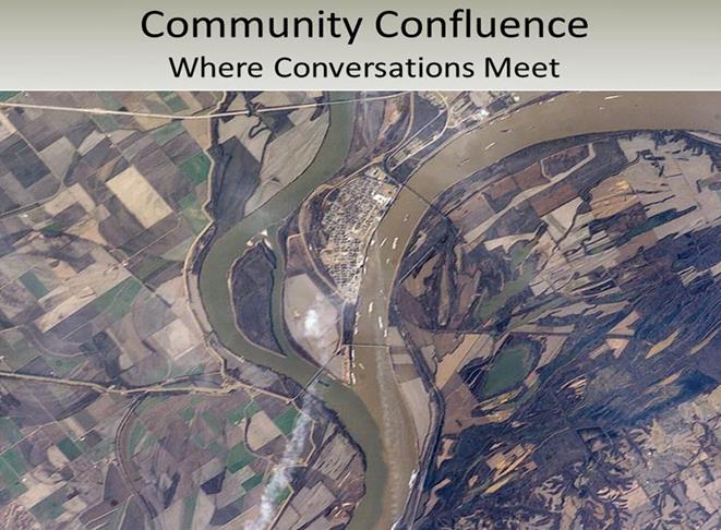
Community Confluence: Where Conversations Meet
divider
Event to be held at the following time, date, and location:
Thursday, January 30, 2014 from 6:30 PM to 8:00 PM (CST)
Maplewood Community Center
Room C & D (doors open at 6:15 pm)
2100 White Bear Avenue
Maplewood, MN 55109

View Map
Share this event:
Facebook Twitter LinkedIn
divider


This is a reminder we have our Community Confluence: Where Conversations Meet event coming up next Thursday, January 30th, 2014.  If you would like to attend please click on the green 'Attend Event' button above.  We look forward to seeing you there!

We would like to invite you to gather with us along with your friends and neighbors as we look forward to the next 10 years in the Watershed. We collected your concerns and solutions through our fall Community Conversations meetings and also through phone calls, emails and social media sites. Click HERE to find a summary of the input we’ve received so far.


Now it’s time to prioritize those issues and actions to provide guidance in developing our 10 year watershed management plan! We welcome all to attend. Please pass this invitation on to anyone you think may be interested.

Come enjoy awesome refreshments and music and share your valued input! For more information contact Sage Passi, Watershed Education Specialist at sage.passi@rwmwd.org or 651-792-7958.


Share this event on Facebook and Twitter

We hope you can make it!

Cheers,
Ramsey-Washington Metro Watershed District
eventbrite
Eventbrite

Dec 13, 2013

The View from another Angle

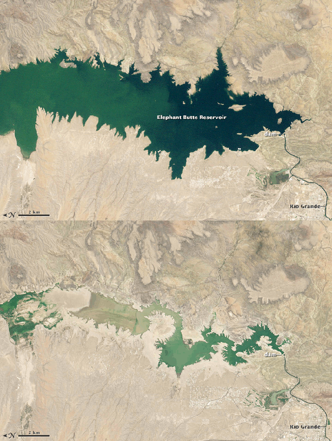
This is our first winter in 17 years to be away from our Little Canada home and Savage Lake. Right now, we're parked above what used to be a giant New Mexico lake, Elephant Butte Lake State Park, and I can't help reflect on the turn of events that changed the climate so drastically for people in this area and how that same sort of change would affect us in Minnesota.

This is the view from outside of our RV. What isn't obvious is that the "lake" is barely a pond. All of that sandy "beach" you see between the water and the edge of the campsites used to be underwater. Suffering from a decade-long drought, New Mexico has become "the driest state in the nation"; but not by much. When we left Texas, we drove past dozens of dry or nearly-dry man-made lakes, most of which were surrounded by abandoned or down-scaled mansions that reflected an opulent lifestyle gone wrong.

When our VW-based Winnebago suffered electronic problems due to exposure to 350 miles of ice, sleet, and snow in western Texas, we stayed with friends in a small town south of Albuquerque while waiting for car repairs. At first, we were a little surprised at how decimated their yard was; just like all of the yards in this part of New Mexico. Our dog never figured out how to deal with the overwhelming tack-burrs that covered a good bit of their backyard. When they explained that they have been under water-rationing rules for about ten years and even had to let their fruit trees die to comply with water regulations, the condition of the yard seemed minor in comparison. Their descriptions of how lush and green the area was when they first moved here, 15 years ago, seemed completely incompatible with the place we've experienced.

On this trip, we've passed thousands of acres of abandoned grape vineyards, apple orchards that appear to be either dead or dying, and some of the most parched farm land I've seen in my lifetime. So far, this drought isn't up to the historical worst years of the area, but it's not over yet.

I've been surprised at how callously and carelessly Minnesotans treat lakes and rivers, coming from a near-desert state, Kansas, and having spent several years in places where water was about as accessible as oil. Our little "watershed" is a good example of how a neighborhood, city, state, and nation (considering the abusive way the Interstate intersected the lake) can blow off one resource because there are others more substantial. The state DNR (Does Not Respond?) plays games with pretending to be working at eradicating invasive weeds downstream from Savage Lake, while ignoring the fact that our lake is a seed bed for these plants, upstream from the treatment. MNDOT uses the lake to drain off sediment and contamination from the freeway, clogging their own drains with runoff and slowly filling the lake with sand and salt. The county and  city salt the roads and washes sediment directly into the lake, filling the edges with sediment and contamination. The attitude seems to be "We have 'real lakes' and water in abundance, why worry about this little pond?" Texas and New Mexico used to have "real lakes," too. Now they'd be happy to have clean drinking water and enough water to manage minimal agriculture.

There are been three major droughts in this area in the last 75 years, including the Dust Bowl years. A large part of the country is going without water for normal activities and we might be wise to pay attention to what happens when the most precious resource on the planet goes away. This flashing photo depicts Elephant Butte Lake in 1994, at 89% of capacity, and this past September, at 3% capacity. It doesn't take long for a precious resource to vanish.

Sep 16, 2013

Community Conversations in the Watershed - Central Area

Thanks to Barbara Marsh, I learned tonight that there is a meeting tomorrow night about the following topics:

To get in on this conversation, you need to register for the event at: http://www.eventbrite.com/event/7785150595.

Obviously, one of the most critical topics regarding our lake should be the sediment allowed to drain from the freeway into the lake and the uncontrolled invasive plants that have taken over the lake.

Sep 8, 2013

Spot Crime in Our Neighborhood

Here is a handy tool for looking at neighborhoods, including ours, around the country: SpotCrime.com. Getting right to our general area can be found here: http://spotcrime.com/#45.016030%2C%20-93.09723.