Jan 22, 2014

Watershed District Meeting

In case you weren't on the mailing list:

You are invited to the following event:
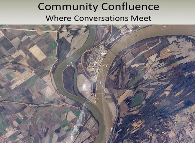
Community Confluence: Where Conversations Meet
divider
Event to be held at the following time, date, and location:
Thursday, January 30, 2014 from 6:30 PM to 8:00 PM (CST)
Maplewood Community Center
Room C & D (doors open at 6:15 pm)
2100 White Bear Avenue
Maplewood, MN 55109

View Map
Share this event:
Facebook Twitter LinkedIn
divider


This is a reminder we have our Community Confluence: Where Conversations Meet event coming up next Thursday, January 30th, 2014.  If you would like to attend please click on the green 'Attend Event' button above.  We look forward to seeing you there!

We would like to invite you to gather with us along with your friends and neighbors as we look forward to the next 10 years in the Watershed. We collected your concerns and solutions through our fall Community Conversations meetings and also through phone calls, emails and social media sites. Click HERE to find a summary of the input we’ve received so far.


Now it’s time to prioritize those issues and actions to provide guidance in developing our 10 year watershed management plan! We welcome all to attend. Please pass this invitation on to anyone you think may be interested.

Come enjoy awesome refreshments and music and share your valued input! For more information contact Sage Passi, Watershed Education Specialist at sage.passi@rwmwd.org or 651-792-7958.


Share this event on Facebook and Twitter

We hope you can make it!

Cheers,
Ramsey-Washington Metro Watershed District
eventbrite
Eventbrite

Dec 13, 2013

The View from another Angle

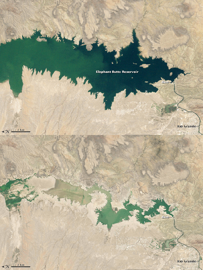
This is our first winter in 17 years to be away from our Little Canada home and Savage Lake. Right now, we're parked above what used to be a giant New Mexico lake, Elephant Butte Lake State Park, and I can't help reflect on the turn of events that changed the climate so drastically for people in this area and how that same sort of change would affect us in Minnesota.

This is the view from outside of our RV. What isn't obvious is that the "lake" is barely a pond. All of that sandy "beach" you see between the water and the edge of the campsites used to be underwater. Suffering from a decade-long drought, New Mexico has become "the driest state in the nation"; but not by much. When we left Texas, we drove past dozens of dry or nearly-dry man-made lakes, most of which were surrounded by abandoned or down-scaled mansions that reflected an opulent lifestyle gone wrong.

When our VW-based Winnebago suffered electronic problems due to exposure to 350 miles of ice, sleet, and snow in western Texas, we stayed with friends in a small town south of Albuquerque while waiting for car repairs. At first, we were a little surprised at how decimated their yard was; just like all of the yards in this part of New Mexico. Our dog never figured out how to deal with the overwhelming tack-burrs that covered a good bit of their backyard. When they explained that they have been under water-rationing rules for about ten years and even had to let their fruit trees die to comply with water regulations, the condition of the yard seemed minor in comparison. Their descriptions of how lush and green the area was when they first moved here, 15 years ago, seemed completely incompatible with the place we've experienced.

On this trip, we've passed thousands of acres of abandoned grape vineyards, apple orchards that appear to be either dead or dying, and some of the most parched farm land I've seen in my lifetime. So far, this drought isn't up to the historical worst years of the area, but it's not over yet.

I've been surprised at how callously and carelessly Minnesotans treat lakes and rivers, coming from a near-desert state, Kansas, and having spent several years in places where water was about as accessible as oil. Our little "watershed" is a good example of how a neighborhood, city, state, and nation (considering the abusive way the Interstate intersected the lake) can blow off one resource because there are others more substantial. The state DNR (Does Not Respond?) plays games with pretending to be working at eradicating invasive weeds downstream from Savage Lake, while ignoring the fact that our lake is a seed bed for these plants, upstream from the treatment. MNDOT uses the lake to drain off sediment and contamination from the freeway, clogging their own drains with runoff and slowly filling the lake with sand and salt. The county and  city salt the roads and washes sediment directly into the lake, filling the edges with sediment and contamination. The attitude seems to be "We have 'real lakes' and water in abundance, why worry about this little pond?" Texas and New Mexico used to have "real lakes," too. Now they'd be happy to have clean drinking water and enough water to manage minimal agriculture.

There are been three major droughts in this area in the last 75 years, including the Dust Bowl years. A large part of the country is going without water for normal activities and we might be wise to pay attention to what happens when the most precious resource on the planet goes away. This flashing photo depicts Elephant Butte Lake in 1994, at 89% of capacity, and this past September, at 3% capacity. It doesn't take long for a precious resource to vanish.


Sep 16, 2013

Community Conversations in the Watershed - Central Area

Thanks to Barbara Marsh, I learned tonight that there is a meeting tomorrow night about the following topics:

To get in on this conversation, you need to register for the event at: http://www.eventbrite.com/event/7785150595.

Obviously, one of the most critical topics regarding our lake should be the sediment allowed to drain from the freeway into the lake and the uncontrolled invasive plants that have taken over the lake.

Sep 8, 2013

Spot Crime in Our Neighborhood

Here is a handy tool for looking at neighborhoods, including ours, around the country: SpotCrime.com. Getting right to our general area can be found here: http://spotcrime.com/#45.016030%2C%20-93.09723.

Jun 10, 2013

So Far, So Good

It is finally spring in Minnesota and, so far, the lake is reasonably clear of lilies. The milfoil, however, is going great guns. I noticed that the county or DNR dosed Lake Gervais with some toxic chemicals for undisclosed reasons. Making the wild assumption that this might be because of the runaway invasive species, it seems sort of backward and half-baked to blow resources downstream while allowing the supply lakes and ponds to run rampant with these invaders. Maybe the country is unfamiliar with how water flows?

May 17, 2013

MnDOT & Little Canada Sound Barrier Final Proposal

The city's MN Pass Municipal Concent document was delivered to everyone concerned in February. It's worth reading. Apparently, construction on the Mn Pass lane and the rest of the project should begin this summer.

One of the statements in the document that I thought was most "entertaining" was one that stated:


The idea that this giant sand "island" could have come from anything other than MnDOT's crappy drainage design is a huge warning that some monkey business is likely to result from an assortment of bureacrats passing the blame around until the barrier is built and nothing is done about the sediment damage. Any idiot can see the drainage pipe is completely buried and backed up and that the overspill from the ramp is continuing to deposit crap into the lake. Over the years since the last construction, I've watched the characters from the Watershed District paddle out, measure random stuff and paddle back without anything good coming from their "efforst." Even to them, it ought to be obvious where that sediment is coming from. For about a year, there was a plume of crap spreading out from the pipe after every rainstorm. It only took a year for the pipe to clog and the damage to be pretty much complete. However, in the years I've spent fighting for our disregarded and damaged lake I've found that MnDOT and, especially, the DNR hire specially "talented" idiots with no clue, concern, work ethic, or personal honesty. The best we can do is hope for the best, but expect the worst.

Both ends of the lake, northeast and southeast, have been harmed by excessive freeway runoff. The old docks at the southeast end have been hauled out of the water and twisted out of shape by the obscene amounts of sediment runoff. The new Gopher drainage design just dumps Gopher's parking lot crap straight into the lake. At this rate, we can probably expect the lake to fill in a few years and development to being in the resulting mosquito swamp. Sometimes it feels like we're living in Florida (and that is not a compliment).