Showing posts with label city council. Show all posts

Feb 11, 2024

Does it still matter?


A friend saw this article from the Star Tribune and sent me this picture from that short piece.The picture looks like it could have come from our old backyard. This isn't even close to the first time this issue has come up. One of the many motivations we had for selling that house was the constant abuse and disregard the city and state demonstrated for that small, historic lake; reclassified as a "watershed" to make the abuse "legal." MNDOT trashed the lake, first with total disrespect in the 1970s by "bridging the lake" with thousands of tons of dirt dumped on the frozen lake to be used for the freeway construction in the spring. That caused flooding in the lower houses on the east side of the new freeway, buried a good bit of the underground water supply for the lake, poured pollution into the lake, and quickly demonstrated the traditional European invaders' disrespect for anything held sacred by Native Americans. Just that act makes a feeble attempt to rename the lake for political correctness another addition of insult to the injury. 

While we lived on Lakeshore Drive, from 1997 to 2015, we saw countless demonstrations of how little the state of Minnesota and the city of Little Canada cared about that once-beautiful little lake. When we first moved into our home, which had been owned by a goober who used the backyard as a practice course for drunken Bobcat parties and who regularly plowed refuse from his "landscaping company" down the hill into the lake, there was still some life in the lake. My grandson and I built a small deck from our yard, out of fallen trees the previous owner had littered all over the shoreline, and we'd watch catfish, perch, and other small fish bob for pieces of bread he'd toss into the water. 

The city actually, illegally, hired a UofM prof and a pack of nitwits to poach Canadian Geese from the lake for several years before residents (loudly led by Ms. Day) embarrassed them into stopping that practice.

That first summer, the local high school maintenance department dumped a few hundred gallons of toxic chemicals into the school's drainage ditch, which made its way to the lake and killed hundreds of fish. Of course, neither the DNR, the Ramsey County Watershed District, or the state's EPA bothered to even reprimand the school's employees and no thought whatsoever was given to repairing that damage. From then until we left, the only fish we ever saw in the lake were minnows and few of them.  At least one business on the north side of our portion (west) of the lake regularly dumped manufacturing chemicals into a drain that kept that end of the lake coated with petroleum rainbows. 

In 2008, the Watershed District  engineers "designed" a new drainage system that, accidentally, lowered the lake level by at least two feet. As a demonstration of how "complicated" determining where that drain level should have been set, my 9-year-old grandson designed an experiment that we documented for his grade school using string, a level, and a tape measure.

MNDOT "designed" various freeway drainage systems that filled the lake with sand, salt, and roadway contaminates peaking (during our time there) with the 2010's expansion of the freeway and a drainage ditch from the south-going Little Canada Road freeway entrance that immediately filled the meager remains of the spring and turned the lake from a feeble remainder of a lake (that once had a "deep end" that exceeded 8') into a rapidly filling swamp with no spot on the lake that couldn't be walked across. Of course, the slackers who get paid way too much to prevent this kind of thing at the state's EPA, the DNR, and the totally worthless Watershed District bureaucrats were busy cleaning their fingernails or counting the money that appeared on their desks in unmarked brown paper bags as that all happened. (After 18 years trying to defend our backyard lake from all of those worthless deadbeats, I have no respect for any of those departments or their employees.)

 For us, the final insult-to-injury nail-in-the-coffin that convinced us to sell our beloved home was the pointless, overpriced, dysfunctional "noise wall" that served to prevent freeway traffic from seeing the eyesore our lake had become. There is no acoustical justification, even based on MNDOT's own guidelines, for a 15' wooden wall placed hundreds of feet from the nearest property it is intended to "protect." COVID did a far more effective job of lowering the health-endangering noise levels (averaging 91dBA in our backyard during the summer and fall of 2014) from I35E in our neighborhood by reducing traffic massively for 2 years. However, as the wall was being constructed MNDOT got serious about directing freeway contaminants into the lake and the south end of the west side of the lake rapidly filled in and became so overrun with sand, salt, and silt that one of our neighbor's dock was literally lifted out of the water. Waterlilies flourished as the lake level dropped.

One of the reasons we ended up staying in Minnesota for the past 28 years was my wife's dream of living on a lake came true when we found our Lakeshore Avenue home in early 1997 just before my promised transfer back to Denver was due. We kept a kayak and a canoe near our dock and used it regularly on that lake, even as it was being overwhelmed by pollution, invasive plants, and noise. We defended the migrating birds who visited our lake from neighbors and government officials. We regularly argued for the preservation of the lake and its wildlife, usually unsuccessfully. A few of our neighbors were also strong advocates, including Rocky Waite (the name change advocate in the Trib article) and a few were obviously oblivious to the lake and did not consider its existence to be of value. A name change is the least the state owes this lake and its history.

May 17, 2013

MnDOT & Little Canada Sound Barrier Final Proposal

The city's MN Pass Municipal Concent document was delivered to everyone concerned in February. It's worth reading. Apparently, construction on the Mn Pass lane and the rest of the project should begin this summer.

One of the statements in the document that I thought was most "entertaining" was one that stated:


The idea that this giant sand "island" could have come from anything other than MnDOT's crappy drainage design is a huge warning that some monkey business is likely to result from an assortment of bureacrats passing the blame around until the barrier is built and nothing is done about the sediment damage. Any idiot can see the drainage pipe is completely buried and backed up and that the overspill from the ramp is continuing to deposit crap into the lake. Over the years since the last construction, I've watched the characters from the Watershed District paddle out, measure random stuff and paddle back without anything good coming from their "efforst." Even to them, it ought to be obvious where that sediment is coming from. For about a year, there was a plume of crap spreading out from the pipe after every rainstorm. It only took a year for the pipe to clog and the damage to be pretty much complete. However, in the years I've spent fighting for our disregarded and damaged lake I've found that MnDOT and, especially, the DNR hire specially "talented" idiots with no clue, concern, work ethic, or personal honesty. The best we can do is hope for the best, but expect the worst.

Both ends of the lake, northeast and southeast, have been harmed by excessive freeway runoff. The old docks at the southeast end have been hauled out of the water and twisted out of shape by the obscene amounts of sediment runoff. The new Gopher drainage design just dumps Gopher's parking lot crap straight into the lake. At this rate, we can probably expect the lake to fill in a few years and development to being in the resulting mosquito swamp. Sometimes it feels like we're living in Florida (and that is not a compliment).

Jun 23, 2011

Cattails and Minnesota Revisited

Hopefully, you've all recieved notice from the city that Little Canada will, again, be paying for our DNR property permits for spraying the lillies. Please get the forms back ASAP so we can get on with the spraying before the plants start to flower and seed. The earlier the better. And don't forget to thank Joel Hanson (joel.hanson@ci.little-canada.mn.us) and the city council members for getting this started without our having to rattle their cages. The work we did last fall definately had an effect on the lillie growth this year and the high water is helping, too. We might just get our lake back if we keep after it.

Jan 31, 2011

"Unweave the Weave" Landscaping

The February-March edition of the Little Canada Le Petit Canadien mentioned that about $250,000 will be made available for landscaping to recover some of the damage done by the increased width of the freeway and to moderate some of the noise that came with that freeway traffic. All I can say is, "it's about time." I've monitored the sound pressure level in my backyard during rush hour and the noise level far exceeds EPA and OSHA safe limits; well into the low 90dBSPL territory.

The Canadien article suggested that the City Council has "focused on the area between I-35E and West Savage Lake in an attempt to create some natural barriers to the sound and view coming from the freeway." This is a solid approach. The extended barriers on the east side of the lake have reflected additional noise in our direction, which makes safely enjoying our neighborhood and yards impossible during much of the day. Hopefully, the character MnDOT used as an "acoustic expert" won't be involved in this analysis, since pretty much all of his guess-timates about the effects on our neighborhood from the freeway expansion and the noise barriers were so far off I'd be surprised if that guy ever attended a science class at any time in his life.

Sound absorption is a much better tactic for silencing noise than obstruction. The noise barriers have a limited effectiveness, based on height, length of the barrier, distance from the noise source and the target clients, the noise bandwidth, and the mass of the materials used for the barrier. Absorption actually converts sound energy to heat; not a lot of heat, but that energy is no longer sound. Noise doesn't bounce off of conifers. Instead, the air motion pass through the branches and leaf tissue and moving those obstacles converts sound to motion and heat.

Of course, the trees will absorb some of the carbon dioxide, lowering pollution levels. In all, this is a plan my wife and I have been advocating for almost a decade and I'm glad to see the city and state buying into it. We should all give Joel Hanson a call at 651/766-4040 or email at joel.hanson@ci.little-canada.mn.us and get the city behind this idea. With decent sized plantings, almost immediately we could have a substantially more quiet neighborhood. In a few years, this could be our view of the freeway.

Sep 27, 2010

In City Council Notes

8/25/2010: The City Administrator reported that the spraying of lily pads in West Savage Lake has begun pursuant to the permit issued by the DNR. The Administrator commented on the process in obtaining the permit and the fact that five of the twelve abutting property owners were denied permits since the DNR indicated there was no evidence of recreational use of the lake by these residents. One of the denials has since been rescinded, and the four other property owners receiving denial may appeal. The Administrator reported that the process has been frustrating, and he has sought the help of the City’s State Representative in this matter. However, he was not sure that the matter would be resolved in time to spray this year given the small window that the DNR allows for the spraying to be done.

[Note: I received the following email from Joel Hanson, City Manager in reply to my inquiry about making an earlier application for next season's permit.]

-----Original Message-----
From: Joel Hanson [mailto:joel.hanson@ci.little-canada.mn.us]
Sent: Wednesday, September 22, 2010 3:02 PM
To: T.W. Day
Subject: RE: [Savage Lake, Little Canada, Minnesota] Bits of the Mission Accomplished

Tom:

Thanks for the updated pictures. I drove by the area last week and could definitely tell you had applied some chemical.

I did discuss this with the Council at our Workshop on Monday. They approved paying for the permit for one more year and I'll get it applied for later this fall.

The Council did indicate that any future permits (after 2011) will be the responsibility of the land owners, but they felt is warranted to pick up the cost for another year.

JH

Sep 5, 2010

Fall and Herbicides

It looks like we managed to spray our herbicide on the lilies about the time they would have died naturally. Hopefully, that means next spring's crop will be slowed up a bit.

It struck me that the permit process is probably an annual deal, with a September 1 expiration. If that's so, we ought to have the city apply for next year's permit as soon as possible. Then, we'll have the whole growing season to attack those things and, maybe, keep the lake free all season.

Aug 30, 2010

The Results

My dog and I ventured on to the lake this morning to review the damage done by Rodeo. I'm a little disappointed, but not surprised. While Dow hasn't tested Rodeo on water lilies, they suggest using the recommendations for "spatterdock"; which was a 3/4-1% solution with handheld application or 6 pints/acre as a broadcast spray. That recommendation also includes "Apply when most plants are in full bloom. For best results, apply during the summer or fall months."

We missed the full bloom moment by about 2 months. Dow states "Annual weeds will general continue to germinate from seed throughout the growing season. Repeat treatments will be necessary to control later germinating weeds." We, obviously, missed the opportunity to continue eradication through the growing season and hit the plants near the end of their normal life.

Considering this was our first attempt to get control of these long-term invasive plants, I'm not discouraged by the results. Next year, we should get after these weeds before they completely overrun the lake. The effort will be more productive, easier, and will allow us all to enjoy the lake throughout next summer.

One of the worst aspects of letting the lake degrade is the insect invasion; particularly mosquitoes. In past years, when the lake shore was a hot bed of bugs, we could always paddle out into the lake to escape both the heat and the pests. With the lily coverage, that is no longer true. All of these flying, crawling, slithering irritants have homes on the lake, thanks to the lily infestation. Between the mosquitoes and the weeds, a trip around the lake is less than relaxing.

Aug 22, 2010

In City Council Notes

August 11, 2010: The City Administrator reported that a DNR Permit has been obtained for spraying of the lily pads on West Savage Lake. That permit includes spraying to obtain an open area around the island and channels connecting properties to the open area. However, the permit excludes five properties from having a channel. The Administrator indicated that he will discuss this with the DNR and likely appeal the restriction.

Blesener asked if Mr. Day had been contacted with regard to coordination of the spraying effort. The Administrator indicated that he has sent an email to Mr. Day and asked to set up a meeting to coordinate the spraying approach.

Aug 7, 2010

In City Council Notes

We're not even close to the forefront of our council's attention, but this is what has been said about our lake in the most recent meetings:

JULY 28, 2010: Nothing

JULY 14, 2010: Mayor Blesener announced that the current level of Savage Lake is very close to its normal levels. It is currently 1 to 1 ½ inches below the lake outlet.

JUNE 21, 2010: Nothing

JUNE 9, 2010: Nothing

Jul 7, 2010

Lily Eradication

The plan to clear a good bit of our lake with herbicide is in place and the city is ready to pay for permits and the necessary materials. Once the permits are approved, John Bibeau and I are going to apply the herbicide by canoe. The city has sent a letter, with application forms included, to all of the west side lake shore owners, which must be completed and returned to the city by July 12, if you want to have your property's water access joined to the central lake area. The central areas will be cleared regardless of how many lakeshore owners request boating and recreational access.

Filling out the blanks in the form may be slightly tricky, if you don't know the length of your shoreline or the distance from your property to the proposed cleared central area or the 10' channel that will be cleared around the island. I talked to Joel Hansen about the values needed in the form and he said the DNR isn't looking for precise numbers, particularly for the distance from your property to the cleared central areas, but he provided a great resource for getting approximate numbers: the Ramsey County GIS Users Group and the mapping resource available at that site (http://maps.metro-inet.us/RamseyCoGIS/CXviewer.htm#). Give the form your best estimate and get it in on time.

Even if you know the information requested in this form, I recommend you bookmark these sites for future reference.

May 29, 2010

Plants and Alge

In the June/July 2010 issue of the city's Newsletter & Recreational Guide, Le Petit Canadien, I saw that the city is concerned with the water quality in Round Lake. Due to the political clout of the groups in that area, the city has "constructed storm water ponds to treat water before it enters Round Lake" and other water management improvements. Unlike our neglected lake, the Ramsey-Washington Metro Watershed District (RWMWD) is carefully monitoring that lake water and attempting to control the lake's problems.

Our lake, especially the west side, is suffering total neglect from both the city and the Watershed District. Employees from the RWMWD occasionally enter Savage Lake from our property and take samples of something, but those results are not published or provided to residents. I admit that I'm unlikely to be impressed by the analysis of any agency incapable of measuring water levels with basic tools available to the average carpenter, but I'd appreciate knowing what they think they have found; even if I doubt the basis and capacity for their conclusions. We aren't even listed as a monitored resource on their website, although Round Lake is and it is substantially less of a lake than the combined Savage Lake areas.

The east side of Savage Lake is considerably less damaged, since it isn't part of the freeway drainage system. However, lilies are starting to appear and the water quality is less than ideal. Other than water depth, I'm not sure what is protecting east Savage Lake from the worst of the plant invasions. Whatever it is, I wish we had some of it.

On a positive note, the starting spring water levels did some nice things for animal life. Painted turtles made a nice comeback in the lake. On one canoe outing, my grandkids and I spotted almost 50 turtles sunning themselves on logs around the shoreline. We also saw some large snapping turtles, one was approximately 20" from nose to tail and came up, twice, to check out my canoe paddle to see if it was edible. The lake was host to two pairs of common loons in early April, but they kept moving after a couple of days in our lake. For one evening, we hosted an off-course white pelican. Two pairs of geese had chicks about the time the temperate dropped and none survived. We lost a few mallard chicks from early hatching's at the same time. Currently, there are about a dozen wood duck chicks and a half-dozen mallard chicks trying to avoid the snappers. If you've ever seen a baby duck vanish from the group when a snapper pulls it under, you know what kind of challenge those parents are experiencing. We also have had a few hawks, herons, egrets, turkeys, lots of redwing blackbirds, cardinals, orioles, sparrows, swallows, and the usual winged culprits. A lot of our lakeshore neighbors have made their backyards into safe habitat for these birds and the animals are taking advantage of their hospitality.

Earlier this spring, with above previous spring water levels in our lake, it looked like we might avoid the previous overwhelming infestations of lilies and other invasive plants. However, that cursed east side drain effectively and rapidly lowered the water levels and the lilies are about to take over the lake, again. Our water levels have dropped 4" last week and we've lost about 9" of water level since the end of the early April rains. At the peak, the water levels were still 5" short of historic levels (based on shoreline measurements from our beach) at the peak point, so we are currently 14" low and dropping. The drain is currently out of the loop, since the east side water level is about 4" below the overspill barrier.

Last year, the City Manager claimed he was polling lake residents for the permit to spray herbicides on the lilies. However, the two residents who volunteered (the previous year) to do the spraying were not asked to either give permission or to help with the polling of property owners, so I suspect we are so far off of the city's radar that we might as well be in Wisconsin.

The freeway is still draining into the west side of the lake, through the slope and drainage design of the freeway just south of the edge of the lake. Boat docks on the southeast side of the west lake have been pushed up and damaged by the sediment and that will only get worse without storm water sediment ponds similar to the ones constructed to protect Round Lake. Without some sort of organized resident action, I think it is safe to say this lake is doomed to become a mosquito-breeding swamp. This spring has been worse than usual, mosquito-wise, and I expect it will go downhill from here.

Our property values were significantly lowered due to the current economic depression (at least ours were) and it only makes sense that the destruction of the lake and the harmful and illegal noise levels our backyards are subjected to from the freeway "improvements" would lower them further. As beautiful and rare as the homes and backyards facing Savage Lake are, anyone with a lick of sense would avoid purchasing these properties for those critical property valuation reasons. I expect to see property values fall a lot further before this is over. The only rational time to show a home on Savage Lake is after midnight when the freeway traffic noise is moderate and buyers can't see the lake clearly.

Last year, I distributed fliers to every house on the lake, informing residents of this website and the opportunity for lakeshore owners to form a property association to protect and promote our lake. I didn't pick up a single subscriber to the Savage Lake, Little Canada, Minnesota website and we totally went off of the City Council's radar for the entire year of 2009. If you are a Savage Lake resident and you have any insights on how we might reclaim this once-beautiful neighborhood resource, we'd appreciate your opinions.

Sep 6, 2009

The Little Canada Deer Hunt

During the August 12th City Council meeting, the longest discussion was about managing the deer population in the city. Apparently, the city's "herd" has increased from 21 head in 1999 to 71 in 2009. Some of our neighbors have been complaining, although they were unnamed in the meeting (as usual), about "plant damage and vehicular accidents."

As an aside, this citizen complaint rumor tactic was used for justifying the "goose roundup" last year. It would seem that a reasonable accounting of the actual number of complaints, who made the complaints, and a minimal bit of evidence would be desirable if the city is going to spend money and take this kind of time out of a city council meeting to discuss these issues. Putting something like this on the agenda, because the "City Administrator reported that he has received a number of calls" is a pretty poor use of the city's time.

John Moriarty, a Natural Resources Manager for Ramsey County Parks, recommended "a sharp-shooter" at $350 a deer. I wonder if he can suggest someone who'd be willing to take a contract on deer for that kind of money? If we're going to pay a local hitman $350 a deer to get the numbers down to the 1999 herd size, we're going to be coughing up $17,500. That would buy a lot of deer repellent and if it turned out that the "number of complaints" was as sparse as the goose complaints, we'd probably have deer repellent in stock for a few decades. Oddly, Moriarty said "noted that if a deer is shot at and the shot misses, that deer becomes trained to avoid the area." Seems like some well-placed fireworks could chase the deer out of the complaining neighbors' yards, if that's the case. I particularly enjoyed the comment that a deer trailing blood and guts across the neighborhood would produce "disadvantages from the public perception standpoint."

You think?

John Sculley was on hand to complain about deer on his property, but said "the only ones who will hunt Sculley property are named 'Sculley.' Sculley indicated that his brother and nephew are bow hunters and capable of taking some deer on his property."

The deer hunting party was tabled for further consideration. In the meantime, look forward to the possibility of bow hunters and sharp-shooters in your neighborhood any day now.

Aug 4, 2009

Who They Represent

The sad status of our lake has made me wonder who works for us and who doesn't? So, I created a map of where our mayor, city council members, and city employees live (as best I could based on city information and the white pages). The results were interesting. Most interesting is that the White Pages has John Keis listed as a St. Paul resident (533 Brimhall St, St. Paul, MN) while he lists his residence as 3094 Payne Avenue on the Little Canada website.

I was a little surprised to see that two council members, Shelly Boss and Michael McGraw, live on the poor side of the freeway (Boss lives at 62 Bryan Street East and McGraw is listed at 179 Little Canada Road East). That's encouraging, if a little difficult to understand. Rick Montour, Joel Hanson and Bill Blesener live almost exactly where I would I would have predicted.

My difficulty is in understanding how their positions on our lake can be so hostile to our side of the lake and so unconcerned with its condition. Honestly, I expected them all to live wrapped around Gervais Lake, which also depends to a mild degree on the water supply collected by the poor side of Savage Lake.

JULY 22, 2009 MINUTES LITTLE CANADA CITY COUNCIL

JULY 22, 2009 MINUTES LITTLE CANADA CITY COUNCIL
Mr. Rocky Waite appeared before the Council to discuss issues related to Savage Lake. The City Administrator began by reviewing the 2008 Goal and Action Plan related to Savage Lake water quality. He noted that the first task in the Action Plan was to address the lake level. The Administrator noted the discussion that occurred at the October 20, 2008 Special Meeting of the City Council. At that meeting the DNR and the Watershed indicated that they would not support an increase in water level feeling that the Ordinary High Water (OHW) mark set for Savage Lake was appropriate.

The next task outlined in the Action Plan was to eradicate lily pads. The Administrator noted the discussion on that topic that occurred on 10/20/08, and pointed out that the person the City had been dealing with at the DNR has moved to another department. The Administrator reported that the permitting process for lily treatment is more complicated than first thought as individual property owners must obtain permits for treatment adjacent to their property with the City obtaining a permit for treatment in the main part of the lake. Two property owners on the lake are coordinating the permitting process.

Task 3 was the dredging of the wetland at Demont & Jackson Street, and the Administrator reported that this work has been completed. Task 4 was the evaluation and installation of storm water improvements. The City Administrator reported that the City Engineer has done the evaluation portion of this work. Funding for the improvements is being sought from the Watershed District. The Administrator noted that cost estimates are over $100,000. Blesener noted the money that the City has already spent to improve water quality, i.e. dredging the drainage pond at Jackson/Demont, purchase of a street sweeper, etc.

Blesener agreed that additional water quality enhancements would need outside funding.

The Administrator indicated that the Watershed District is evaluating the potential for funding a pilot project of this nature and will report back to the City.

Task 5 was to evaluate the purchase of a street sweeper, and the City Administrator reported that the sweeper has been purchased jointly by Little Canada and the City of Falcon Heights. The Administrator reported hat Little Canada has been swept twice this year and there will be a third sweeping in the fall. Task 6 called for the evaluation of pre-wetted salt spreading, and the Administrator indicated that given the reduced amount of sand used on City streets, thus reducing sediments, this task is no longer relevant.

Rocky Waite reported that he has discussed the issue of the lake level with both the DNR and the Watershed District. Waite stated that it was his belief that the water level is not where it should be. He indicated that the DNR set the OHW level in 2004 as a result of Harold Schrunk from the DNR looking at Savage Lake, noting the level at that time, and declaring it to be the OHW level. Waite indicated that the DNR did not take into consideration the historic data relative to lake levels in setting the OHW level. Waite reported that he has those documents which include building permit information and information relative to the lake level in the vicinity of Gopher Electronics. Waite reported that when the City Engineer did elevations, he did not check the Highway Department profiles that were done prior to 1979. Waite stated that in 2004 the DNR merely looked at Savage Lake and stated that the current elevation was the OHW level.

Waite questioned previous comments made by the Mayor relative to the operation of the old gate system on the lake which indicated that after heavy rains a board or two was removed to lower the water levels on East Savage.

Blesener pointed out that determination of the OHW level is the responsibility of the DNR, and the City has no authority to determine that level. Blesener also pointed out that the Watershed shot the levels of the homes on East Savage and the weir level was set accordingly. The Watershed determined that there are a couple of homes on East Savage that would be in danger of flooding if the water level was raised. Waite referred to Council meeting minutes from May of 1963 that referenced the OHW level of Savage, and felt that information should have been taken into consideration in determining the OHW level.

Blesener pointed out that there are a lot of regulations that have changed since 1963, and again noted that it is the DNR and the Watershed that have determined the OHW level for the lake. The City has no authority in determining lake levels.

The City Administrator agreed that the DNR sets lake levels, and reported that the Watershed did a hydrological study of Savage Lake. He noted the information outlined in the 10/20/08 meeting minutes relative to the determination that the 100-year flood elevation for the lake is 897.9 and that there are a number of homes close to or below the 100-year flood elevation. The Watershed indicated that raising the weir structure would endanger two or three homes.

Waite stated that he would like to see the West Savage Lake level raised to a point where life would return to the lake.

The City Administrator reviewed the history of the weir system on East Savage and the City’s request of the Watershed to do something with the system when the old one became inoperable. The Watershed then installed a permanent weir structure that would require less maintenance than the old one.

The City Attorney reported that a lot of lake regulations have changed since the 1960’s and 1970’s and noted that ownership of lake best was removed to the State in the late 1970’s. The Attorney reported that the regulation of lake levels is unquestionably the responsibility of the DNR. The Attorney indicated that the City would only be able to lobby the DNR relative to changing the lake level. The DNR has final jurisdiction.

Waite suggested that an L-pipe system be installed that would raise the lake level of West Savage without impacting the level of East Savage. Blesener felt that a dam system of the connection between East and West Savage would result in West Savage filling up and East Savage drying up.

Waite felt the water levels would even out between the two lake segments.

McGraw questioned how the L-pipe would cause West Savage water levels to increase when the lakes are not spring fed. McGraw pointed out that the lake levels are decreasing because there has been no moisture. Every lake in the metro area has been drying up.

McGraw stated that he hears what Mr. Waite is saying, but did not agree with taking water from East Savage for the benefit of West Savage. He did not believe this was fair and equitable. Blesener indicated that he would support Mr. Waite’s request if all property owners on East Savage supported it. Blesener felt that was doubtful.

Waite did not believe the L-pipe would result in East Savage drying up, pointing out that eventually the water level would reach a point where it would overflow the pipe and the excess water would go into East Savage.

Blesener noted that the lake level is currently 2 to 3 feet from the weir, and pointed out the lack of precipitation over the summer. Blesener suggested that Mr. Waite approach the DNR with his request to raise the lake level, as it is the DNR that regulates lake levels.

Waite indicated that he is trying to find a solution for the lake. He noted that there is little wildlife left in or on West Savage. He was also concerned that there were chemicals coming into West Savage.

Blesener noted that the Watershed is responsible for water quality. The City Administrator pointed out that at the October 20th meeting Cliff Aichinger stated that it was very expensive to test for chemicals when you do not know what you are looking for. The City Attorney reported that Metropolitan Council Environmental Services (MCES) has a program wherein homeowners gather water samples and MCES will test them.

Blesener suggested that the City Administrator check into this program and get the information to Mr. Waite.

Mr. Waite then presented pictures of the property conditions at Gopher Electronics which showed a discarded tire, leaves and other debris. He noted that there is a MN DOT storm water discharge pipe that is filling with sand. There is also a sand bar going out into the lake from a freeway outlet. Waite pointed out that MN DOT had indicated that there was no freeway storm water being discharged into Savage Lake. The City Administrator reported that the Public Works Superintendent contacted MN DOT and was told that the storm water pipe at the northeast corner of West Savage is an abandoned pipe. There is a small sand delta in this area, but it is MN DOT’s position that removing the delta would do more damage than good.

Waite asked how deep the sand deltas were. The City Administrator pointed out that the City Engineer had done some analysis of the deltas and agreed that removal would cause more damage than good. Waite felt that the lake was so low at this point and a better analysis of the depth of the sand deltas could be done. McGraw noted the damage that would be done in removing the sand deltas as the property around West Savage is fully developed. Waite felt the deltas were deep and if the lake could be dredged to a depth of 15 feet, West Savage would be restored to a lake again.

McGraw asked Mr. Waite to outline his requests.

Waite replied that he would like to see the weir raised. He was unsure as to how much but suggested a range of 1 ½ to 3 feet. He felt the lake level should be raised to a point just under the top of Don Smith’s wall. Blesener suggested that if the lake level were raised 1 ½ feet, the water would be over the top of this wall.

McGraw asked how Mr. Waite proposed that the City cause the weir to be raised. Waite requested that the City get behind his request and propose it to the Watershed and the DNR. Blesener noted that it is the DNR that has the authority to control lake levels. The City Administrator indicated that even if the City could support the increase in lake level, the property owners around East Savage will likely not support it given the Watershed’s study that shows two or three homes would be at risk.

Waite noted that when the Watershed did their study they did not take into consideration the historical levels of the lake. Waite pointed out that the freeway fence was never moved and the culvert was never moved.

Keis asked if Waite’s position was that raising the West Savage water level will resolve all other concerns. Waite thought that was true as raising the water level will cause the lilies to go away.

McGraw suggested that the City contact the DNR, its State Legislators, and the Watershed and indicate its support for raising the water level. McGraw noted that the DNR has the ultimate control and will respond to the City’s letter documenting their position on this issue. McGraw felt that this response should be the final decision and put the matter to an end.

Waite again commented on the actions of Harold Schrunk from DNR in visually looking at Savage Lake in 2004 and declaring that the level of the lake at that time was the OHW level. Keis stated that this is what Waite believes was done, but there may have been more analysis into the OHW than that. Waite indicated that he has Schrunk’s field notes.

Blesener recommended that the City Administrator write a letter to the DNR and Watershed requesting that the OHW level be reviewed. Blesener also noted that Savage Lake is not considered a lake.

Waite asked about the Gopher Electronics property concerns. Blesener directed the City Administrator to contact Gopher Electronics and ask that they clean up their site. The Administrator reported that Gopher Electronics had indicated in 2008 that they would work with the Watershed about the issue of surface water from their parking lot flowing into Savage Lake. The Administrator indicated that he would follow up with Gopher Electronics.

The Council reported that City staff would keep Mr. Waite informed as to the status of letter to the DNR and Watershed.

Apr 30, 2009

Spring Is on the Way

Finally, spring is on the way. You can tell because the lillies are popping up all over Savage Lake's western half. It won't be long before the lake will be covered with the DNR's precious invasive weed and all other signs of life in our lake are choked out.

Last year's bout with the Ramsey County Watershed District and the DNR bureaucrats left us with limited options for preserving our neighborhood lake. Although long-term residents on the lake pointed out evidence that the water levels "measured" by those bureaucracies had serious calculation errors, we ended up in our usual position of being told "this is all you are going to get" in no uncertain terms. This is why voters often call for regime changes. I'd be all for eliminating the DNR and renaming that disorganization "Hunting and Fishing Promotion." The state could use an EPA that actually, actively protected natural resources, but the DNR is not up to that task.

After a dry winter and, so far, a dry spring, the lake level is the lowest it has been at this time of the year since Elvy and I moved to our home in Little Canada in 1997. We have never experienced a spring with water levels so low that we have drag our canoe 15' from our boat rack to a shore so shallow that we have to wade another 10' through the mud to find enough water to float the canoe. Nothing even the all-powerful and infinitely-useless DNR can do could have done more damage to the lake than a drought. If we don't get a lot of rain, soon, this will be a terrible year for our lake.

I spent a good bit of time walking the lake this winter. Since it was frozen solid for almost 4 months, I had time to prowl all over the west side lakeshore. It is obvious that a lot of recent damage to the lake came from the freeway construction and the runoff from that widened and reshaped roadway.

On the northeast end, the drain (supposedly now capped) poured sediment at such a high rate that the outlet in the lake is all but completely filled. I have pictures of that outlet from early last spring that show more than 3/4 of the drain pipe was exposed and that the sediment "island" was only a few feet long. Now, the pipe is all but closed up and the island extends 25-30' from the pipe outlet.

At the southeast end of the lake, the downward slope of the freeway directs the runoff from the road directly into that end of the lake. We're not talking abopt a 20" drainpipe here. This is several hundred yards of highway and ditch system all aiming runoff into the west side of Savage Lake. Anyone foolish enough to claim that this isn 't an intentional attempt to turn our lake into a catch basin for highway runoff is too incompetent to employ in any serious engineering capacity. The freeway security fence has been repaird, I think, at that end of the lake. It was, apparently, destroyed during the freeway construction and it took almost a year before an effort was made to repair it.

Speaking of foolish excuses for engineers, the unemployable character who claimed to have done a noise survey justifying the lack of barriers or other noise protection for lake residents before the freeway expansion was started ought to be among those looking for work today. My own measurements during the winter found that the new freeway traffic upped my backyard noise level by as much as 8dBC (No, you acoustically uneducated moron. I did not use A-weighting for noise levels of 82-91dB unweighted. A-weighting is for low-level noise environments, typically 55dB unweighted and below. Only government stooges use A-weighting in high noise level environments.) At some point, Little Canada neighbors will have to face the fact that this freeway "improvement" has seriously degraded our home investments and selling prices will reflect that fact. The best we can hope for is $10/gallon gas.

Finally, from walking around the lake this winter, it struck me that we have two problems on the two halves of the lake and we've been treating them as if they were a single problem with a single solution. On the east side of the lake, poorly considered planning and development has resulted in a water level limit that prevents the current limited drainage system from being raised to a level that returns the lake to a historic height. On the west side, no such limitations exist. All of our homes are 20' or more above the lake level and even basements are considerably above any resonable water table issues. So, the one thing we haven't been considering is changing the inlet height that feeds the east side of the lake from the west; the pipe that passes under the freeway. That inlet could easily be redesigned to raise the west side lake levels by several feet without putting the east side housing in jeopardy. Something to consider, since we seem to have come to an impass on fixing the Watershed's drain design flaws at the east lake.

I don't have much information about the status of the lake on the east side of the freeway. If any residents would like to add information about that hemi-lake's condition, I'd be happy to post it here.

Jan 12, 2009

10-20-2008 Lake Shore Owner's Meeting

This is somewhat old news, but since my notes ended up on a computer that I rarely use these days, I'm late in posting it.

10-20-2008 Meeting

Officials Present:

Bill Dircks – Public Works Superintendent
Cliff Aichinger – Watershed District
Neil Vanderbosch – DNR
Lee Elfering – City Engineer
City Council Members

Information

Early on, it was declared that the DNR and Watershed District have decided that the current oversized, improperly positioned lake drain is an immobile object. The DNR is claiming the oversight in preventing the lake from being raised to previous levels. The Watershed District has decided that their latest attempt at correcting their original mistake will be their last attempt. The city is confused and isn’t sure who to believe.

“Nobody called me,” Neil Vanderbosch said in reply to a citizen’s request that the state review its position on water lilies. He seemed to believe the policy that if government is unresponsive, government has no responsibility. I know that I wrote, emailed, and called the DNR several times in 2002 asking for assistance with the artificially low lake height. I’m not even close to the only local citizen who called the DNR, Watershed District, city officials, state legislators, and anyone else who might have been able to help if anyone else had given a damn.

Vanderbosch continued his comedy act by saying, “We can’t go on individual lakes. We’d never get anything done,” regarding the DNR’s ability to review our lake’s situation. I’ve only been in Minnesota for a dozen years, but I’ve not yet seen any evidence that the DNR gets anything done outside of inflating their bureaucracy and attending meetings in resort areas (particularly during winter months). I guess it’s true that if the DNR bothered with monitoring individual lakes and rivers, it would be more difficult for them to attend junkets in Hawaii.

The one piece of information I obtained from questioning Vanderbosh is that the Division of Waters should be in charge of monitoring water quality. Now, I need to figure out who is in charge of the Division of Waters.

Proposed Actions

Dredging the “wetlands” (at the corner of Jackson and Demont) and other drainage issues

This “wetlands” was designed to route water from Demont to Savage Lake, trapping sediment before reaching the lake. The wetlands hadn’t been cleaned “since the mid-80s.” Elfering has recommended not removing sediment from the other lake sediment inlets. Elfering is pushing rain water gardens and strongly argued against drain traps due to the maintenance costs and effort required. If the gardens are built, they will try to get started on them during the winter.

One drawback to the gardens is that they will prevent some water from getting to the lake. Another drawback is that they won’t take back any of the existing damage to the lake.

Preventing water from reaching the lake

The city is planning on switching to all salt winter street treatment to reduce the sediment from the streets. Bill Dircks said the city is planning on sweeping more often and earlier in the spring and through the summer. He is recommending a vacuum or regenerative air sweeper to remove both the small and large particulate material. The City is planning on purchasing a regenerative air sweeper at a cost of $50,000 more than a traditional sweeper. Pre-wetting the salt should reduce the need for quantity (30% less salt) and increase the effectiveness. Other salt delivery systems are also being considered.

Ye Old Water Level Controversy

The water level, supposedly, is currently at 895.4’ above sea level. The DNR lists the lake height at 898’. Mayor Blessner requested that the DNR’s numbers be revised to match the Watershed District’s number. This is newspeak at its finest. If the current claim to being the “right height” doesn’t match the old data, we’ll just revise the old data and hope nobody notices. In the meantime, the lake continues to fill with sediment and the level continues to drop.

Resolutions

The city resolved to have the city engineer look further into having the state highway department pay for dredging the sediment that was dumped into the lake near the freeway.

The city offered to pay the DNR fees and the chemical costs for spraying the water lillies next spring. Thomas Day and John Bibeau volunteered to be responsible for spraying the lake according to the DNR specifications.

Dec 11, 2008

Taxes and Bureaucrats

Every time I’ve had an “experience” with a Minnesota state bureaucrat, I’ve wondered what makes westerners so much more interested in democracy than easterners. By that statement I mean, most western states put a bit in state government’s mouth with their referendum system. Eastern states, apparently populated by less involved semi-citizens, are big believers in non-participant “representative government.”

The older I get and the more powerful communications technology becomes, the less faith, or interest, I have in representative government. It was a rational system when it took a new President or Senator two months to ride a horse to Washington to take office, but it’s absolutely primitive today. Every major function of government, including budgeting, could be voted on, electronically, by citizens and the bureaucracy would be left with only the task of serving the public good. If they fail at their task; that department’s funding would reflect that failure in the next budget. With our current system, failure appears to be justification for more funding.

Now, to the local point at hand.

I received my 2009 Proposed Property Tax statement. The Ramsey County website indicated on the bill (www.co.ramsey.mn.us/prr) explained that “Ramsey County property appraisers will be available for individual market value consultations in adjacent rooms beginning at 5:30 p.m.” Along with hundreds of other Ramsey County taxpayers, I attended this meeting and took a number for my “individual market value consultation.”

After waiting for two hours, I was led to a desk where a “consultant” told me, “You understand that there is nothing I can do to lower your property tax evaluation here?”

Of course, I or the other 300-500 citizens waiting for a consultation understood no such thing, but he proudly pointed to the small print on the statement that said, “The period to discuss possible changes has passed and changes can no longer be made to your property valuation. It is included here for your information only.” The people who write this crap for the county must take an English as A Foreign Language writing course before they are allowed to print gibberish on official paper.

If the title of the form is “2009 Proposed Property Tax (their italics and bold print, not mine), you’d think that changes, in fact, can be made. I’d love to know what noun the “it” in “It is included” refers to.

I was told by one bureaucrat that it was a relatively simple matter to protest the county’s appraisal, which should reflect current market values including duress sales (fast approaching the majority of sales in the current market). The “consultant” to whom I was assigned, however, told me that the 2009 property evaluation was based on the 2007 market value and could not be revised to reflect the real market. I was warned that any attempt to take this issue to Minnesota Tax Court would require a several hundred dollar private appraisal, and would be contested by the county.

I am going to accept that challenge and cause exactly as much trouble for that department as possible. Hell, I might even hire a lawyer just to wrangle my property evaluation down to a realistic value. I’d rather spend the money on a private lawyer than these arrogant county deadbeats.

Here are some references for your personal fight:

The Pioneer Press, that uber-conservative property value booster that it is, recently stuffed a report back in the Business section explaining that Twin Cities property values are down "19 percent from the median of $216,500 [to $175,000] during the same month last year." The article tried to invent a stabilizing trend by claiming that "traditional" listings were only down 2 percent from the previous year, but asking price and selling price are growing more distant every day we drift further down this several-year recession path and toward a national depression.

From my experience tonight, I can tell you several places where I'd make massive cuts in the state and county budget.

Nov 15, 2008

Ramsey County Tax and Budget Meeting

The following information is copied from the Ramsey County Truth in Taxation site:

Ramsey County Tax and Budget Meeting
Arlington High School Great Room
1495 Rice Street
St. Paul, MN
December 11, 2008 - 6:00 p.m.This is a combined public meeting of your county commissioners, school board, city council, and metropolitan special taxing districts to discuss proposed 2009 budgets and proposed 2009 property taxes. You are invited to attend these meetings to express your opinions.Ramsey County property appraisers will be available for individual market value consultations in adjacent rooms beginning at 5:30 p.m.Interpreters will be available for deaf/hard-hearing, and also for Spanish and Hmong speaking participants. Handicapped accessibility will be provided.

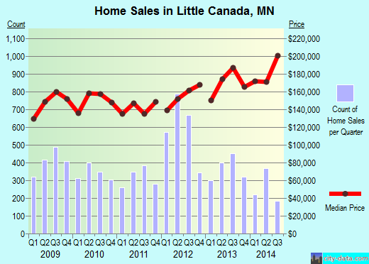
The above chart is a look at what has happened to Little Canada property values and home sales in the past year.

For example, according to my Ramsey County Property Records and Revenue statement, my home's "Taxable Market Value" fell 5.4%. Obviously, this is significantly more optimistic than actual home sales reflects (-22%), according to the city-data.com information (which is based on actual home sales not anticipated tax revenues. You'll note that sales has dropped off dramatically in the last year, too. Even the $140,000 average sale price is questionable, since so few houses have been sold (even though there are many more houses for sale in the city than there were in 2007).

So, I'll be meeting with an appraiser on December 11th to argue my home's Taxable Market Value down to a more realistic value. I recommend you do the same. There is no point in paying taxes on imaginary evaluations and this is money that belongs in your pocket, not the state, county, or city's.

Oct 9, 2008

10-8-2008 Little Canada City Council Meeting

Tonight, one of the last items on the City Council’s agenda was Savage Lake water quality. Before the meeting, Joel Hansen dropped a packet off at many Savage Lake homes describing the history of the lake, some of the problems, and the options available to the city and residents. One of the suggested remedies for the lake has been rain water gardens. Residents were asked to bring a signed copy of an approval form if there is interest in installing rain water gardens on Savage Lake yards.

Joel summarized the recommendations of the city, the Watershed District, and residents. The Watershed District’s measurements stated that the “100 year flood” level and their estimation of the current lake level would not allow for an further change in the lake level. The DNR has allowed for chemical irradiation of up to 5 acres of water lilies on the west Savage Lake. There is some discussion still left regarding the weir design and height.

Joel discussed recommendations for a different street sweeping system to pick up more of the “fine particulate” material from the streets. That involves a $200k purchase of equipment, which members of the council (especially the Mayor) balked at. They discussed cost sharing the equipment with another community.

I asked that the city look into containing the runoff from the freeway into the east side of the lake. Joel admitted he hadn’t included that in the summary, but he was working on that issue. In retrospect, I realized that the freeway runoff should be the responsibility of the state, particularly DOT. I offered to obtain pictures of the sediment traps used at the Shakopee Arboretum to provide to Joel as a design possibility.

Joel will call for a neighborhood meeting to discuss and describe the remedies for the lake. October 20th, at 7PM is the proposed meeting date.

From the city's meeting notes:

SAVAGE LAKE WATER QUALITY ISSUES
The City Administrator reviewed his October 3, 2008 report on the Savage Lake water quality action plan which was directed last summer after a neighborhood meeting held by the Watershed and City staff.

The Administrator reported that the first action plan task dealt with lake level. The Administrator indicated that research has been done and some conflicting information found, however, it appears that the lake level has always been very close to the current outlet level of 895.1. The Administrator noted that the Watershed has conducted an elevation survey of nine homes around East and West Savage Lakes that appeared to have the lowest elevations as compared to the lake level. The results of this analysis is that the 100-year flood elevation is only .2 feet above the low entry elevation of the shop garage at 334 Little Canada Road. Based upon Watershed rules, they cannot support any increase in the normal elevation as that would increase the 100-year flood elevation. Given the elevation of the lowest structures, that would put them in the 100-year flood plain. The Administrator reported that one possible modification was suggested by Little Canada resident Tom Wenzel, a senior water resource engineer with the MN Board of Water and Soil Resources. He suggested modifications to the hydraulics of the new structure to better match those of the former culvert. This would slow down the removal of flood waters, thus resulting in more flood detention, increased residence time, periodic increases in flood elevations, and hopefully have some impact on how much the lake drops below the current elevation as the summer progresses. The Administrator reported that the Watershed will be evaluating this option.

The second task was to determine the feasibility of eradicating lily pads. The Administrator reported that he has met with Mr. Neil Vanderbosch, Aquatic Plant Management Specialist with the DNR, who indicated that a full eradication will not happen. The Administrator indicated that Mr. Vanderbosch will be revising the plan he previously prepared to indicate the level of eradication that will be acceptable. He has indicated that a maximum eradication of 5 acres is acceptable for large bodies of water, and has suggested that 3.5 acres may be the most that will be approved for West Savage Lake. The Administrator reported that it is an expensive undertaking to contract for eradication. The Administrator suggested an economical option would be for the City pay the cost of the chemical if there are residents on the lake willing to apply it.

Blesener asked for clarification on the outlet weir (normal level). The City Administrator noted the correspondence from the Watershed indicating that the top of the weir is 895.4, which was raised from 895.1 in 2006 to compensate for the tip in the outlet pipe. The Administrator noted the need for the DNR to modify their information to correspond with the 895.4 level. Blesener pointed out that the 100-year flood elevation is only two to three inches below the Smith’s garage floor elevation.

The Administrator reviewed task 3 for dredging the wetland at Jackson and Demont. The City Engineer will have plans and specs ready for this work by the end of the month to be completed over the winter. He will include alternates for the sediment plumes in areas of Savage Lake noting that access to these areas will be difficult.

Task 4 relative to evaluation/installation of storm water improvements. The Administrator noted that the installation of rain water gardens in the Savage Lake drainage area is the most reasonable option. Surveys were recently mailed to property owners in the drainage area to determine the level of interest. Survey information is due by October 15th. The Administrator indicated that the plan would be to have these rain water gardens installed next summer.

Task 5 calls for the evaluation of a street sweeper purchase. The Administrator reviewed the two types of sweepers, noting that the regenerative air sweeper is favored by the Watershed as it picks up the fine particulates which carry the most contamination. The cost of a regular sweeper is estimated at $140,000 versus $200,000 for the regenerative air sweeper. The Administrator indicated that the Watershed has been approached relative to funding a portion of this cost as a demonstration project. The Administrator also indicated that the cost of this equipment could be included in the City’s Capital Improvement Budget or funded with LGA dollars depending on the level of future LGA funds. Blesener suggested that another option would be a joint purchase with another city, and suggested that City staff explore this option. The City Administrator indicated that staff is currently discussing a shared sweeper with neighboring cities. The City Administrator indicated that should a sweeper be purchased, the goal would be to hire a retired individual to operate the sweeper on an as-needed basis. With the purchase of a sweeper, the City’s streets could be swept more frequently, thus improving water quality, appearance, etc.

Task 6 calls for the evaluation of pre-wetted salt spreading. The City Administrator indicated that this task is still being evaluated.

Tom Day, Lakeshore Avenue resident, stated that he appreciates the work that the City is doing with regard to Savage Lake water quality. He indicated that there are two additional issues that need study. The first is the freeway run-off coming to West Savage Lake and the fact that the drainage pipe is full. The City Administrator indicated that staff would check on this issue. The second issue is the drainage from the north side, and Day suggested the installation of sediment traps. Day indicated that he would obtain some pictures of these traps.

The City Administrator suggested that the next step would be to call for a neighborhood meeting to review study progress with the neighborhood.

Mr. Blesener introduced the following resolution and moved its adoption:

RESOLUTION NO. 2008-10-250 – SCHEDULING A NEIGHBORHOOD MEETING FOR MONDAY, OCTOBER 20, 2008 AT 7:00 P.M. TO REVIEW THE SAVAGE LAKE ACTION PLAN UPDATE

The foregoing resolution was duly seconded by Montour.
Ayes (4).
Nays (0). Resolution declared adopted.

Jun 30, 2008

Savage Lake meeting 6/17/2008

From: Oyen, Cameron
Sent: Wednesday, June 18, 2008 3:32 PM
To: Cliff Aichinger
Cc: Joel Hanson; barbara.allan@ci.little-canada.mn.us; michael.mcgraw@ci.little-canada.mn.us; lelfering@elferingeng.com; bill.dircks@ci.little-canada.mn.us
Subject: Savage Lake meeting 6/17/2008

Cliff, et al:
Several things arising out of the 6/17 Savage Lake Public Meeting (it rambles a bit, so please read to the end):
1) Thank you! for taking the time to meet with us all; some cranky, some just emphatic, all interested in what is best for a wonderful water resource. Thank you for maintaining your cool in the face of some heavy fire at times.
2) We are truly grateful for the wise and insightful contribution of our neighbor Tom Wenzel to the discussion; he stepped outside the box for a moment and viewed the matter from a different angle. We saw his suggestion to approach the new bureaucrat at the DNR (I can say that, being a bureaucrat myself) about taking another look at the water level assumptions, among other things, as a positive turning point in the discussion. We have at least some hope of positive change, as long as we base the baselines on some real history, as provided by folks who have some, rather than some "one-size-fits-all" bureaucratic standards and interpretations that DO NOT always fit "all."
3) The Oyen perspective began a couple of years prior to our June 15, 2002 move-in date. We had every reason to expect, based on visits to our property and that of our neighbors, whom we knew going back several years, that the water would remain open and that the level would not drop so significantly. From our personal, Savage Lake residential experience, the lake (we do not live on Wetland Shore Ave, by the way - our street name is one thing we hold on to as our proof of "lakedom") was higher in the summers of both 2002 and 2003 than it has ever been since, including its highest this year, a few weeks ago. We now have some shrub roses planted where our 02/03 high-water mark was and the water is still at least many inches lower than this point. Those first two years I even had to be careful when mowing that I did not submerge the mower wheels at the edge of the lawn. No such problems since.
4) I put in our dock in July 2004 and used waders to do most of it, as the water was 18"-24" at the end of the new dock. At that time, the cattails were no further out than the first three feet of the dock's length, extending into the water. They have now almost completely enveloped the full 19 foot length of the dock, as they seek water that had receded. It was not long after the dock installation that the water went down precipitously and the dock that had been in at least 18" of water was land-locked by mud flats the rest of that summer and nearly all of summer 2005.
5) I think your statement that the water would have been low anyway, even without the new weir is only partially accurate. The new weir did not allow the lake basin, the spring following its installation, to retain spring snow melt and spring rain in order to retain a little depth through the drought. Had more water been allowed to remain, the percolation and evaporation would have had less effect than it did.
6) We look forward to working with our city council, city staff and others to pursue some common sense solutions to the two matters of most concern; water level and weed removal. We truly hope you will advocate with our legislative reps, state agencies and other involved entities to balance any competing interests.
7) Please keep in mind that all we are asking for is a return to the way things were prior to 2004. These are not requests to enhance, but to restore. And since public entity action had a hand in creating the current situation, it makes sense for public entity action to pursue and facilitate restoration, whether the lake is a lake or a wetland, whether it is considered private or public. It is we, the residents of the lakeshore who have been adversely affected, and not by our own action. Please keep these important points in mind as we proceed.
We look forward to taking the next steps.