Showing posts with label department of natural resources. Show all posts

May 17, 2013

MnDOT & Little Canada Sound Barrier Final Proposal

The city's MN Pass Municipal Concent document was delivered to everyone concerned in February. It's worth reading. Apparently, construction on the Mn Pass lane and the rest of the project should begin this summer.

One of the statements in the document that I thought was most "entertaining" was one that stated:


The idea that this giant sand "island" could have come from anything other than MnDOT's crappy drainage design is a huge warning that some monkey business is likely to result from an assortment of bureacrats passing the blame around until the barrier is built and nothing is done about the sediment damage. Any idiot can see the drainage pipe is completely buried and backed up and that the overspill from the ramp is continuing to deposit crap into the lake. Over the years since the last construction, I've watched the characters from the Watershed District paddle out, measure random stuff and paddle back without anything good coming from their "efforst." Even to them, it ought to be obvious where that sediment is coming from. For about a year, there was a plume of crap spreading out from the pipe after every rainstorm. It only took a year for the pipe to clog and the damage to be pretty much complete. However, in the years I've spent fighting for our disregarded and damaged lake I've found that MnDOT and, especially, the DNR hire specially "talented" idiots with no clue, concern, work ethic, or personal honesty. The best we can do is hope for the best, but expect the worst.

Both ends of the lake, northeast and southeast, have been harmed by excessive freeway runoff. The old docks at the southeast end have been hauled out of the water and twisted out of shape by the obscene amounts of sediment runoff. The new Gopher drainage design just dumps Gopher's parking lot crap straight into the lake. At this rate, we can probably expect the lake to fill in a few years and development to being in the resulting mosquito swamp. Sometimes it feels like we're living in Florida (and that is not a compliment).

Jan 20, 2013

Winter Lake Status

I can't explain why, but one of the things we love about our abused and battered little lake is walking on the ice on a moderate winter day. There is something oddly cool about making a lap or two around the island when the sun is out, the lake is frozen solid, and traffic is blasting past us, oblivious of our presence. It's not quiet. It's miles from pastoral, but it is oddly peaceful. A little more snow and the lake would be cross-country ski-able. A little less and, I guess, you could skate it. Before the winter hammer fell on Last Saturday, we were out on the lake enjoying the moderate temperature and windless day.

A few years ago, this was a 3' diameter concrete
culvert. Today, it's packed with freeway sediment.
The lake's level is as low as it has been in years. So low that I was able to take some pretty pointed pictures (say that 3X fast) of the damage MNDOT's past "engineering" has done to our lake. For example, smack in the middle of this shot is what remains of a drainage culvert MNDOT used to drain water (and massive quantities of sediment) from the south-bound I35E Little Canada Road freeway entrance. When we moved to Little Canada in 1997, this drainage culvert was completely exposed and the lake was approximately 4' deep about a canoe paddle's length away from the culvert. That general condition and relative height stayed constant for years (discounting the catastrophic lake level drop when the Watershed District screwed up the water levels at the end of the 1990's) until the freeway redesign a few years ago.

This picture gives some perspective on how large the
sediment "beach" is, at least the above water line.
For a couple of seasons, all of the freeway entrance ramp drainage was routed through this culvert and over the edge of the ramp's curbs until the drainage culvert was filled with sediment. The rest of the silt and sediment is simply poured off of the ramp into the lake, resulting in a dramatically eroded lake shore and an increasingly steep bank. At one time, this was the deep end of the lake by several feet. There was some source of water movement that always kept the ice either thin or clear about 30' west of this point, but after the freeway redesign the massive influx of sediment filled in that source of current and helped allow the nearly complete coverage of water lilies by making the lake shallow enough for them to take root. The sediment shelf is completely above the water-line right now and anyone can walk out and examine the damage done. You can also see the erosion effect by looking at the freeway fence posts. The concrete post footers are being rapidly exposed as the lake bank vanishes from runoff erosion.

This was my first opportunity to see the Little Canada-funded Gopher Electronics parking lot drainage plan and I'm not particularly impressed. We gave this design a shot on the drainage pipe at the south end of our property about 12 years ago and it worked for a season, but was quickly overwhelmed by the quantity of sediment pouring into the lake from Lake Shore Ave and the sediment "island" has continued to expand since. This design is not a "trap," but is more like a temporary diversion with a little landscaping.

Sediment traps are either holding ponds, like those we see along the eastbound sections of the new I694 design, or complicated concrete affairs that have to be regularly maintained. Any man-made system requires maintenance and that is often the fatal flaw in major construction designs. The designs are fine, but the follow-up is insufficient or non-existent. Supposedly, we have traps like the ones illustrated in the mechanical drawings (on the left) for all of our street drains, but if no one cleans the traps they were one more waste of taxpayer dollars.

It's not like all of this hasn't been reported to the city, county, and state in the past, but if you'd like to see what's really going on with our lake, now is the time to take a walk on the ice. Worst case, the lake is about 4' deep at the deepest spot right now. The water levels are probably 2' below where they were early last spring.

If we get the noise barriers and the construction of those barriers doesn't do more harm than good, the quality-of-life value of our lake could improve dramatically. It would be nice to get some of this street and freeway drainage problem solved at the same time so that the lake just doesn't slowly fill with sediment and become a mosquito breeding ground.

Jun 23, 2011

Cattails and Minnesota Revisited

Hopefully, you've all recieved notice from the city that Little Canada will, again, be paying for our DNR property permits for spraying the lillies. Please get the forms back ASAP so we can get on with the spraying before the plants start to flower and seed. The earlier the better. And don't forget to thank Joel Hanson (joel.hanson@ci.little-canada.mn.us) and the city council members for getting this started without our having to rattle their cages. The work we did last fall definately had an effect on the lillie growth this year and the high water is helping, too. We might just get our lake back if we keep after it.

Jun 21, 2011

Where We Are Today

I stopped by the city offices last week to look at the plans for the upgrades to I35E between Highway 36 and the I35E and I694 rats' nest, but the city doesn't have anything to show, yet. Supposedly, we're going to be getting some noise abatement design into the work, but based on the amateur work I saw from the state with the "analysis" of the impact on our homes with the last work on that roadway, I don't expect much value from that. Honestly, if one of my Musical Acoustics students turned in a final project that was as poorly written and analyzed, I'd fail him.


[Note: The clear weather pictures above are from early June and the overcast pictures were taken 6/21/2011.]
The lake water height has been at historic levels almost all spring, thanks to an extremely wet spring. That hasn't, however, had much impact on the lily growth. It is gratifying to see that last fall's Rodeo spraying has given us some clear water this spring, which indicates that we could get control of this pest weed if the DNR weren't an obstacle and the Water Shed District made some sort of useful contribution. Unlike this time last year, we've been able to canoe the lake in the evening and, other than the dramatic increase in mosquitoes, it's nice to have some of our lake back.

The milfoil is another issue. I found some minnows tangled in that crap near our dock, which is a great demonstration of how destructive that weed is. You'd think the DNR and Watershed District would want to aggressively control this crap at the headwaters of our county's major lakes, since lakes like ours feeds all of the big lakes and there will be no way to get rid of the weed without getting rid of it upstream.

There was some noise about how the city was going to make one last contribution to lake shore owner DNR weed eradication permits, but I haven't heard anything new on that subject either. Regarding the milfoil, it almost seems like we're going to have to get out on our shorelines with a rake and drag the junk out of the lake manually.

Speaking of the Watershed District, they use our lake access to make some sort of water sample, drainage analysis a few times every year. I don't know what results from that testing, but you'd think it would be the kind of thing they'd make available to lake shore owners and the city. Anyone have an idea where that information might exist?

Our pair loons left town a couple of weeks ago. I'd become used to hearing them trumpet every morning and when it stopped it seemed like a good neighbor had moved away. I guess we should just feel lucky to have had them for as long as we did.

Sep 18, 2010

Bits of the Mission Accomplished

When I got back from Texas, a week after John and I sprayed, looking at the lake was pretty discouraging. Earlier this week, I was driving past our lake on I35E and I could have sworn I saw the outline of the route John and I took with the canoe and Roundup. Friday, we canoed out into the lake and discovered that canoeing is possible. Today, my wife and I ventured out on the lake with a camera and took some pictures of our lake and, I hope, you can see where John and I whipped up on the lilies; and where we didn't.


The recommended 2nd round of spraying would have really cleaned out the open areas. But you can easily get around the lake and if it's far from perfect it's also far from completely jammed with lilies. The large treated center section is considerably less populated than the untreated edges. Some of the pictures show the difference pretty clearly. The path around the island is less obvious, but in the right light from the right angle, you can see where we were. On the canoe, the cleared area is the only path around the lake.

Some of my wife's pictures show how badly the lake is infected with milfoil. I have no idea how we're going to beat back this contamination, but I suspect that we need some more life in the lake to help with this; animals and fish. There was more life on the lake this afternoon than there was all summer. We spotted a dozen geese, the same number of ducks, a couple herons, and a couple of least bitterns. If we can get an early start with the herbicide next spring, maybe some of the birds and animals will stick around for the summer. The lily infestation pretty much forces the birds to look elsewhere for habitat and hunting.

Sep 5, 2010

Fall and Herbicides

It looks like we managed to spray our herbicide on the lilies about the time they would have died naturally. Hopefully, that means next spring's crop will be slowed up a bit.

It struck me that the permit process is probably an annual deal, with a September 1 expiration. If that's so, we ought to have the city apply for next year's permit as soon as possible. Then, we'll have the whole growing season to attack those things and, maybe, keep the lake free all season.

Aug 30, 2010

Cattails and Minnesota

This is an interesting Pioneer Press TwinCities.com article on a similar invasive plant problem: Cattail Catastrophe. Thanks for sending this, Barb.

". . . Where native cattails once stood, sprinkled among bullrush, smartweed and other plants, now there's almost certainly a vast lawn of narrow-leaved cattails or their hybrid offspring. These relative newcomers are taller, with narrower, darker-green leaves and slimmer "corn-dog" spikes at the tops. They outcompete the natives, upsetting the ecological balance by creating a monoculture that's inhospitable to other plants, animals and birds. . ."

We have quite a few cattails on our lake, but I'm probably not observant enough to be able to recognize which type we have. Having seen how thick and aggressive some of the cattails have been on the southwest corner of the lake, I'm betting they are the "narrow-leaved cattails or their hybrid offspring." Some of you really have a barrier from geese and other wildlife! Of course, you can't see the lake or get anywhere near it, either.

Someone Is Fighting for Us

Apparently, the DNR "experts" are somewhat clueless about lake life cycles and the effect of uncontrolled plant life in a small lake. This comment, in particular, seemed about as ignorant as anything I've heard in the last 9 years from DNR bureaucrats, "water lilies, a native plant that provides wildlife habitat and water quality benefits. Healthy populations of native aquatic plants are integral to the ecological health of our lakes, but they can also hinder recreation, particularly if they are abundant on the lake's surface. The DNR's APM program tries to balance the protection of aquatic plants with the need for lake shore residents to gain recreational access to the water. " The plant is certainly "native" to our part of North America but anyone capable of walking to the lake shore would see that the infestation of plants in our lake is as far from a "healthy population" as is possible.

I'd love to know how the DNR's bureaucratic inactivity could be described as any sort of "program." As far as I can see, the DNR's sole purpose is to burn its budget without any useful benefit to taxpayers. Clearly, Mr. Hirsch has never set foot any where near Savage Lake, east or west or he is severely impaired in many ways.

Here is the text of a communication between our state representative, Bev Scalze, and the DNR commissioner's office. I was particularly heartened by her impassioned, direct approach to getting the DNR off of it's collective butt:

From: Bev Scalze [mailto: Rep.Bev.Scalze@house.mn]
Sent: Sunday, August 29, 2010 12:22 PM
To: Steve.Hirsch@state.mn.us
Cc: joel.hanson@ci.little-canada.mn.us; rep.jean.wagenius@state.mn; Bob.Meier@state.mn.us; Kathy.Anderson@state.mn.us; Mark.Holsten@state.mn.us; Sean.Sisler@state.mn.us
Subject: Re: Savage Lake aquatic plant control issues

Steve,

Thanks for sending the e-mail message.

However, the information that you relayed was information that had already been communicated by the City Administrator of Little Canada, Joel Hanson, and by Sean Sisler.

I would be glad to give you a tour of the area in question, or you may be able to view it on DNR maps prior to 1959 in comparison with the present day maps.

There is a freeway (35E) that bisected the 30-acre Savage Lake in 1959. It now has expanded to 10 lanes of asphalt with on/off ramps at Little Canada Road. The freeway has polluted the lake, and has also contributed to the decreased depth of Savage Lake with runoff. Now the DNR calls the water bodies west Savage Lake and east Savage Lake, which are considerably smaller because of the freeway. The lakeshore property owners, some of whom have lived there for 73 years, have suffered immense damages because of actions of the State of Minnesota and the Federal Government. The DNR Division of Waters should be more interested in the expansion of 35E which occurred in 2009-10 than they are with this current eradication permit request. Was there a DNR permit granted for the expansion? I would like to see a copy of that to compare with the current permit request from the City of Little Canada on behalf of the property owners.

The problem at Savage Lake regarding the denial by Mr. Sisler of the water lily eradication permit applications, is that there could be "anticipated" use that may not be visible to Mr. Sisler from some points of the lakeshore. A lakeshore property owner could have a canoe in a garage, or could possibly have friends or family that would like to bring over a canoe to the lakeshore property and use it for recreational purposes. A lakeshore property owner should not be required to petition Mr. Sisler with photographs and abstracts of their property. That is a very "heavy handed" DNR approach to the situation. The property owners have rights, and Mr. Sisler, or anyone else in his capacity, should not interfere with those rights to limited recreational use of their property. The property owners haven't been asking for clearing out all of the invasive lilies, nor are they asking to eradicate vegetation that helps the health of Savage Lake. To insinuate that they want to interfere with "healthy populations of native aquatic plants integral to the ecological health of the lake" doesn't give much credit to the property owners. They love their lake. They are not asking for long docks to reach open water as some in the state have done recently. They are simply asking for the ability to use their property in a limited recreational manner. Simply put, they are requesting the ability for anticipated access to open water for a canoe, boat or some other legal means. If they could achieve a channel to reach open water, perhaps they could then construct a dock for easier "visible" access. With the current heavy mat of lilies, it doesn't make much sense.

Since 2000, the overgrowth of water lilies has expanded greatly in Savage Lake. They were simply not there before that time in the massive quantities that are they are now. To apply DNR rules for "wildlife habitat and water quality" in a heavy-handed manner in a lake with 10-lanes of asphalt already going through it is simply ridiculous. The DNR's APM program should take into consideration the impact of the freeway on the property owner's recreational use of the lake, and allow these few residents some small amount of consideration and peace as they put up with the noise and pollution created by the State of Minnesota. To simply deny a permit for a channel through the expanding aquatic plants based upon "visible" recreational use is arbitrary at best. The most visible use of Savage Lake is the continuing harm of 10 lanes of asphalt, and that should not trump the rights of anticipated recreational use by lakeshore property owners.

If legislation would help in your consideration of these extreme situations, I would be glad to work with you on that level. Sometimes statewide "rules" are not fair to severely impacted metro property owners because of 10-lanes of asphalt in their lake, and exceptions are in order.

Please contact me with possible corrections to this situation.

Bev Scalze
State Representative, 54B
357 State Office Building
100 Rev Dr Martin Luther King Jr Blvd
St. Paul MN 55155
651/296-7153
651/296-4165 (fax)
rep.bev.scalze@house.mn

From: "Hirsch, Steve A (DNR)" 08/27/10 1:37 PM

Dear Representative Scalze:
Commissioner Holsten forwarded to me your August 24, 2010 email regarding aquatic plant management (APM) issues on Savage Lake. As you know, APM issues can be contentious and I am sorry this one has caused problems for your constituents. I hope you find the following information helpful.

The APM permit request for Savage Lake was to control water lilies, a native plant that provides wildlife habitat and water quality benefits. Healthy populations of native aquatic plants are integral to the ecological health of our lakes, but they can also hinder recreation, particularly if they are abundant on the lake's surface. The DNR's APM program tries to balance the protection of aquatic plants with the need for lake shore residents to gain recreational access to the water.

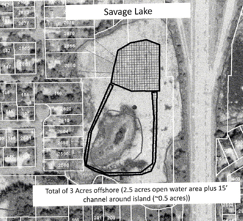
Savage Lake residents were permitted to control 3 acres of water lilies and to clear channels from their shoreline to the open water area. Apparently, some channels were denied because there was no evidence of recreational use along the shoreline. Our APM specialist who did the inspection was very liberal in determining evidence of recreational use; anyone with a dock, boat, canoe, kayak, or paddle boat was authorized a permit. One individual, who did not have a boat on the water, sent a picture of their boat with current registration and the permit was amended within a couple of days to allow a channel for that person. If there are other people in a similar situation, we would certainly be willing to amend the permit for them as well. These folks should contact Sean Sisler (651-259-5807; sean.sisler@state.mn.us) if they wish to amend the permit.

You also expressed concern with the amount of time it took for Savage Lake residents to receive their APM permit, indicating that there was more than a 30-day lag time. In checking with APM staff, however, I learned that DNR received the permit application on July 21 and mailed out the permit two weeks later on August 5. This seems like a reasonable turn-around time, especially since this was a new permit requiring a field inspection prior to issuance.

I hope that this has helped to address your concerns. Please let me know if you need additional information.

Sincerely,

Steve Hirsch, Director
Division of Ecological Resources
(651) 259-5106

The Results

My dog and I ventured on to the lake this morning to review the damage done by Rodeo. I'm a little disappointed, but not surprised. While Dow hasn't tested Rodeo on water lilies, they suggest using the recommendations for "spatterdock"; which was a 3/4-1% solution with handheld application or 6 pints/acre as a broadcast spray. That recommendation also includes "Apply when most plants are in full bloom. For best results, apply during the summer or fall months."

We missed the full bloom moment by about 2 months. Dow states "Annual weeds will general continue to germinate from seed throughout the growing season. Repeat treatments will be necessary to control later germinating weeds." We, obviously, missed the opportunity to continue eradication through the growing season and hit the plants near the end of their normal life.

Considering this was our first attempt to get control of these long-term invasive plants, I'm not discouraged by the results. Next year, we should get after these weeds before they completely overrun the lake. The effort will be more productive, easier, and will allow us all to enjoy the lake throughout next summer.

One of the worst aspects of letting the lake degrade is the insect invasion; particularly mosquitoes. In past years, when the lake shore was a hot bed of bugs, we could always paddle out into the lake to escape both the heat and the pests. With the lily coverage, that is no longer true. All of these flying, crawling, slithering irritants have homes on the lake, thanks to the lily infestation. Between the mosquitoes and the weeds, a trip around the lake is less than relaxing.

Aug 28, 2010

Bev Weighs In

We've received a nice assist from our state representative, Bev Scalze, in the form of a very direct request for management intervention from the DNR commissioner. Savage Lake property owners have at least one friend in a reasonably high place in the Minnesota state government.

Aug 21, 2010

Done

I wish I had more energy to talk about the herbicide application on the lake, but John and I hit the lake at 6:30 this morning and finished at just before 4PM. 6.6 miles of slogging through lilies and milfoil. Because of GPS issues, we stayed well inside of the DNR's application map. 9 hours of plowing that swamp was more than enough work for the two of us. My everything is sore.

This was the first time I've been on the lake since early June, when the weeds took over. The lake is in terrible shape, with very little animal life left on or in the water. We saw about a half-dozen painted turtles, the same number of ducks, no snappers, no geese, no herons or egrets, no minnows or small fish, just bugs and weeds. In 14 years of living on the lake and regularly canoeing it, this was very close to the least life I have seen on it. Usually this time of the year we have birds, adolescent geese and ducks, lots of turtles sunning themselves, and minnows. Not this year.

With the lake in this kind of shape, I have to wonder what the Watershed District folks are doing when they take their monthly prowl of the lake? There is no way anyone even mildly knowledgeable would consider this healthy water: lake or watershed. The good news is that the levels are up, but the lake is, for the most part, dead outside of invasive plant species.

There are some significant patches of little-to-no lily growth that I would like to have explained. The lily outbreak began near the island beaches. In 2000, the only lilies to be spotted on the lake were on the east and south edges of the island. By 2003, that area was beginning to be overgrown as the water level was forced grossly below normal levels by the new drain installation on the east lake. After several years of low rainfall and improper lake drainage, the lilies had spread all over the lake. The sediment drainage from the freeway revision raised the lake floor dramatically at the northeast end of our lake and the normal deep end of the lake began to fill in. All of this contributed to increased plant contamination; which contributes to sediment build-up and even more favorable conditions for plants. This summer, however, the lilies have receded from the island's shores and there are several relatively low water points with very little lily infestation.

Oddly, the east side of the lake looks untouched by all this contamination. Obviously, something significantly different is happening to that side of the lake.

The caution signs should stay out over the weekend, but they can be removed Sunday evening. We have some floats on the lake marking our outer boundaries and I'll remove them Sunday. The Dow Rodeo data says we should begin to see the effects of the spraying after 48 hours. Hopefully, this time next week we will be able to use the lake again.

Aug 17, 2010

On hold because . . .

Today would have been the perfect day to spray the lake. However, John and I are stuck because neither of us have the right kind of GPS unit to run the DNR's software. Because of the precision required from the DNR, we need to be sure we are applying Rodeo exactly where they have allowed us to spray. To do that, we need to be able to map our location accurately, which this software does for us. However, my GPS unit won't accept the software at all and John's is a Cobra unit which is also incompatible. If any of you have a GPS unit that is compatible with this program and would be willing to loan it to us for the herbicide application, it would be greatly appreciated.

Our deadline for spraying the lilies is the end of this month, the permit expires on September 1.

Aug 13, 2010

One Step Closer

“In the Army you never volunteer for anything except certain death.” Or "No good deed goes unpunished." Now that we have our DNR "Permit to Destroy Aquatic Vegetation" approved, the DNR has come up with a long list of hoops for us to jump through.

First, to warn all of you who swim in, drink water from, use the lake's water for "domestic purposes," fish in, irrigate with, and water your livestock from Savage Lake, we have to post a bright orange notice on your property to keep you from doing those things in our lily-covered, mosquito and leech infested, nearly suffocated by invasive plants lake. Pretty freakin' hilarious. The form looks like this (except for being bright orange) and it will need to be posted everywhere a DNR inspector might look.


Second, 5 of the 12 applications for lake access were denied because the DNR guy stood in someone's backyard and looked for evidence that lake shore owners were using the lake recreationally. If you didn't have a boat in plain sight or you hadn't plowed your way through the weeds and lilies into the lake, leaving an obvious path of destruction, the DNR guy decided you weren't dedicated enough to enjoy our lake. If you really want access to the lake, you'll need to call Sean Sisler, the DNR's "Aquatic Plant Management Specialist" and plead with him to reconsider his decision. The stories I've heard of conversations with these DNR bureaucrats make me want to move to Montana and vote for the entire Libertarian party ticket.

Finally, Mr. Sisler has required us to do the spraying at a time convenient to another DNR bureaucrat, Steve Hanson, because he's convinced we're not as competent as one of the DNR's approved contractors and "the label is the law and the chemicals must be applied according to the label instructions." Having worked on several projects with Minnesota state and St. Paul city-approved contractors and the bureaucrats who mismanage them, I have to feel insulted.

The DNR has been a constant source of misinformation and obstruction regarding the damage they have done to our lake in the last decade and any hope of restoring Savage Lake to reasonable condition. I'm sure they will continue to provide this sort of nitpicking as we try to follow their constantly moving targets.

On the other hand our city manager, Joel Hanson, has really gone out of his way to help with this. He picked up and delivered the DNR forms and the chemicals today and provided us with a lot of useful information for using Dow's Rodeo herbicide. He is wrestling with the DNR over the denied access permits and has worked hard in our interests. If we get this done without more interference from the DNR, we should have a block party and make Joel a guest of honor.

Aug 11, 2010

The Permit is Here

Joel received the approved "Permit to Destroy Aquatic Vegetation" from the DNR on Tuesday, the 10th. Mostly, our application was approved as submitted.

However, several lake shore homeowners will not be getting their channels to the cleared area because the DNR deemed those properties has having "NO REC USE." I don't know what that means, but I'll get more information from Joel this week and I'll let you know what I find out.

I think the end result is that those 15' channels to the open area will only be cleared for 7 of the 12 property owners who applied for relief from the lily infestation.

I have a copy of the official DNR form, in PDF format, and if you would like a copy please email me through this blog or directly to my home email: twday60@comcast.net. A copy of the list of lake shore owners' and the result of their application is at right.

Aug 7, 2010

So Tired of Waiting

Approximately one month after submitting the application to the DNR and we're still waiting for their response. Since that slow-moving, dysfunctional bureaucracy has no actual function, except to burn taxpayers' money, we have no leverage on them. The DNR sat by and watched our lake turn into a mosquito breeding swamp and did everything it could to restrict any actions that might have saved Savage Lake.

Now that the city and lakeshore residents are trying to take that responsibility into their own hands, the DNR is doing what it does best: nothing. With an annual budget of "$835.1 million" you'd think they might be interesting in accomplishing something with that giant outlay. You'd be wrong. In one of his rare moves that I agree with, Pawlenty "unallotted $2.950 million for the biennium"2010-2011 from the DNR's budget. I'd recommend unalotting a whole lot more until the bureaucrats in the DNR realize that they have to earn taxpayers' money. Currently, they obviously feel they deserve that outlay simply because past DNR employees actually worked for a living.

Yeah, I'm disgusted. I was disgusted by the babble I've heard from DNR representatives at every Savage Lake meeting since 2004 and I'm even more disgusted with that collection of inert bureaucrats today. If any state representative or administrator wants my vote, all they have to do is promise to de-fund the DNR and I'm on their side.